Wednesday, October 24, 2012

The End of the Road

Every ending is a new beginning, but we wondered if we would actually get to the end so we could start again.

The drive from Yermo to Santa Cruz was uneventful, if long. We had hoped to perhaps stay in Paso Robles for a little wine tasting, but the temperatures were too hot to leave the dogs in the MF. So we made it home, parked MF, and didn't go back into it for about 2 days, we were that thankful to be out of it.

After a full day of unpacking and then cleaning out the dog hair, it was time to return MF. Here is its finally voyage down the road.

I had located a dump station nearby the CruiseAmerica return center, but that is when the fun began. When we arrived, there was a Class A ahead of us doing its dump of the tanks. After waiting until it was finished, the Class A wouldn't start. So he asked for a jump. After setting that up, and jumpstarting the Class A, it wouldn't stay started. Turned out he had run out of gas. So he went to get gas, then I jumped it again, but it wouldn't stay on. After about 1 hour of this, I was ready to burn it down in place, since it was apparent it wasn't going anywhere. But the dump station owners figured a way to back in MF close enough to the dump station to allow me to clean out the tanks, and I high-tailed it out of there. For all I know, that Class A is still there, rotting.

Then I went to the gas station right next to the return center to fill the tanks (they would have charged $7/gal if it wasn't full, which actually is pretty close to what gas is in CA these days ;-). But the pump would only put $85 of gas on the credit card. So tried again, and it rejected the card, so I had to use a different CC. At this point it seemed that gods were conspiring against us, and that we would never be rid of MF.

But we did get it returned, and we were free and clear.

Overall, we had a great time. There is some great scenery in the US, and everyone should get the opportunity to see it. If you can stand the driving, aren't on a time schedule, and able to deal with unforeseen circumstances, it is an experience you don't want to miss.

It also helps to have a very strong relationship with your partner and family, because there will be times it is tested. We are very fortunate to have all of these items.

Tuesday, October 16, 2012

Day 20 - Yermo, CA

Where in the heck is Yermo, California? Well, it's just east of Barstow, off Hwy 15. Yup, in the middle of no freakin' where.
After leaving Flagstaff, we decided to make some headway toward home. If we stopped in Needles, then we would most likely make another stop somewhere near Bakerfield. With these two exciting possibilities, both Mr. B (back in the saddle for a couple hours today) and I went for some miles today. Just over 350 miles. Our longest and roughest day yet. I-40 between Flagstaff and Barstow is far from smooth, which translated into a very noisy, tiring day.
So, here we are in Yermo. It was pretty hot when we arrived, but it pretty pleasant now with the sun down. Wifi is limited and device specific, but no matter. No pics today.
We may bypass our last stop in Paso Robles. The "plan" was to spend a few days doing some wine tasting. There are some gems in the Paso area, but temperatures are expected in the high 80's to mid 90's. It seems we've come full circle: the beginning and end of our trip are altered by temperature.
Well, it has been three weeks on the road. There is still so much to see and do, but life is calling us back home. There will probably be a couple more blog entries to wrap it all up and say farewell to Mofo.
Until then.

Monday, October 15, 2012

Day 19: Grand Canyon, AZ - Part 2

I left Mr. B today at the Flagstaff campsite and went on a tour to the Grand Canyon. I'm not much for bus-type tours, but I needed a break from driving and the "Big Ditch" was 78 miles away. I figured a van with group of 11 would be manageable. So naive I can still be.
The tour guide was extra chipper (the 64oz soda?) and extra horrible as a driver (the 64oz soda?). As a party of one, I got to sit shotgun and believe me there were times during the drive that I wish a shotgun would have put me out of my misery. She held the microphone portion of her broken headset in her left hand and would more than frequently use her right hand to point. So when she did point, guess how many hands were on the wheel of her speeding vehicle? If the scenery wasn't so compelling, I would have kept my eyes closed.
Despite the adrenaline-filled drive, the views were magnificent. Many of the vistas she took us to were less frequented, but no less beautiful.
This view is from the Yavapai point where the canyon is the widest: 18 miles between the north and south rims! The peak about 1/3 from the right is called Vishnu. To identify the canyon's features, early survey teams used names from different religions because they knew not everyone worshipped the same god. Kinda progressive thought for the late 1800's.
The green butte on the right is Temple Butte. This viewpoint is near the East entrance.
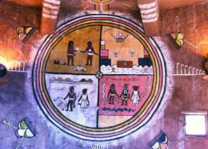
Many of the buildings were designed by Mary Colter during the 1900's-30's. She used materials gathered locally and often had Native American artists decorate the sites. One particular building is the Desert View Tower. Great views from the additional elevation. And this is a mural inside the first floor of the tower.
Sights were seen and the menu Mr. B had for dinner was icing on the cake:
  • Shredded brussel sprouts sautéed with pancetta, finished with basaltic vinegar and parmesan cheese.
  • Smashed potatoes
  • Grilled herb-crusted pork chops
  • Ice-colded Bass beer
  • S'mores
A grand day of sightseeing and a grand dinner with a grand companion.

Day 19: Part 1 - Dog Daze

As Keeper of the Camp and Entertainer of the Dogs, I spent the day doing laundry, running the dogs, shopping for dinner, and then reading a trashy SF novel at the campsite.

The dogs took an intense interest in a squirrel in the other part of the park, who was wise enough to play dead until the dogs lost patience.
Dogs are kinda funny. There are two perfectly good dog beds for them to lay on, but they seem to both have to fight to stay on the favorite one.
Oh, and someone decided to bring an four wheel drive assault RV to the park. These folks are not amateurs.

Sunday, October 14, 2012

Day 18: Holbrook to Flagstaff


This was just a short jaunt (about 100 miles) heading due west on Hwy 40. Even though it was a Sunday, it seemed that most of the truckers were still working, and they all were on HWY 40 heading west. We did gain about 1000ft. in elevation, as Flagstaff is about 6K ft, compared to the 5K in Holbrook. So we are expecting a bit chillier evening.
The KOA in Flagstaff is quite nice, with pine-wooded camping spots - making maneuvering a little more challenging.
Many KOAs have TeePees that you can rent out. These seemed quite spacious and nice.
Since Mrs. B wasn't feeling too well, we just took it easy around the campsite, and had a leisurely dinner of BBQ flank steak fajitas.
And here is another food post. S'mores made by Mrs. B tonight.

Day 17: Painted Desert/Petrified Forest

So, after the lovely storm, we took off early on Saturday from Cortez, heading to Holbrook, AZ. It was 136 miles due south from Cortez to Gallup, then you take a right and head directly west 'til you can't stand it anymore.
While we had been to the Painted Desert/Petrified Forest National Park about 6 years ago, we felt it was worthwhile to do it again. And it was very cool. First, you get to see the Painted Desert on the north side of Hwy 40:
Mrs. B likes to get a little closer to the edge than I do.
You then go across Hwy 40 to the south side and get into some of the other strange rock formations and some of the actual petrified wood.


So, after the park, in was back on the way to Holbrook. And in Holbrook is the probably the largest collection of petrified wood for sale in the world. The place is call Jim Gray's, and if you wanted a 2-ton piece of petrified wood, this is your place. Here is an example:
Oh, and there is an ENTIRE YARD full of it!
We stayed at the Holbrook KOA and they have a pancake breakfast every morning through the end of October, which made staying in Holbrook a bit nicer.

Tomorrow, on to Flagstaff...

Friday, October 12, 2012

Day 16: Riding the Storm Out

Yea, I don't like REO Speedwagon that much either, but it seemed appropriate. We had planned to stay in place as the weather forecast looked ominous, and it did not disappoint. At some point during the night was a hailstorm that sounded like someone was dropping a bunch of ball bearings on the roof. Then there was a parade of thunderstorms throughout the night and until about 11:00 am this morning. But thankfully it wasn't constant, and we were able to take the dogs out without getting drenched.

Here is what it looked like...


But being cooped up all morning made Mrs. B a little stir crazy, so back to Mr. Happy's for lunch, and then we hit a couple stores before going back to the camp and doing the ever-exciting laundry.

The weather is expected to go cold tonight, but at least the western sky does not look as ominous as it did last night.
And a last shot of Mesa Verde, as we move out early tomorrow for Petrified Forest/Painted Desert in AZ.

Thursday, October 11, 2012

Day 15: Anasazi Heritage Center

Today we went to the Anasazi Heritage Center in Dolores, about 10 miles north of Cortez. This center was built when McPhee reservoir was being put in, circa 1984. As one can imagine, water is pretty precious in the high desert area of the Colorado Plateau, and they never had a way to store it in this area. So they decided to build a damn on the Dolores river ("Dolores" means "sorrow", so it is actually "the river of sorrow"). However, because this is the Mesa Verde area and just chock full of ancient (500 AD onwards) relics of native Americans, they wanted to preserve as much as they could. So the area the relics that they found prior to the completion of the damn are preserved in the visitor center. This is also the main visitor center for "The Canyon of the Ancients" which has a ton of both discovered and undiscovered relics of the native American people.

Here is Mrs. B outside of the center...
So you may wonder at the term "Anasazi" (I know I did). It turns out that it is a Navajo term for "enemy ancestors". But, as usual, someone else co-opted the term to describe the ancient Pueblo native Americans, and the term stuck. Full discussion on it here.

Inside were many artifacts of ancient Pueblo culture, and a recreation of an actual archeological dig of a Pueblo habitat.
The center is up on a knoll, and you can see The Sleeping Ute mountain range in the distance.
After that visit, it was back into Cortez for lunch at (and no, I can't make this up), "Mr. Happy's Bakery, Bar, and Grill". Food was quite good. Then we went to the Cortez Cultural Center and saw some more relics, and a really cool quilt collection.
Back at the KOA in the late afternoon, we saw the expected storm start to come in.
I had been monitoring the weather, and they had been warning for a few days that this storm was going to come in sometime Thursday night or Friday. We have decided to wait out the storm here in Cortez another day, rather than trying to travel to Gallup during the possible variable weather on Friday. Saturday's forecast looks good, so we will head down to Gallup, then on to Flagstaff for a chance at the Grand Canyon.
And I realize that blogging about food is frowned upon, I couldn't help but take a picture of the pasta bolognese we made for dinner tonight.

Oh, and by the way, did we mention that it is high up here in Cortez (6,200 ft). Check out the package stress.

Well, we are up to date on our travels. Until the next one.


Day 14 - Mesa Verde National Park

Yesterday I went to Mesa Verde National Park about an hour's drive from our campsite in Cortez. Mesa Verde is one of a few national parks with structures created by human beings. It also is one of the World Heritage sites in the USA.

Mesa Verde has 5000 known archeological sites, 600 of which are cliff dwellings. The people who built these structures are referred to as the Ancestral Puebloans. In the late 1200's, these people moved away from Mesa Verde and gave rise to twenty-four tribes that exist today.

Two of Mesa Verde's largest cliff dwellings were on my agenda: Cliff Palace and Balcony House. By the names alone you should have guessed that Mr. B was not in attendance.

This is the view of Cliff Palace from the overlook. The largest cliff dwelling in North America, Cliff Palace sits ~100 feet below the plateau. Cliff Palace had 150 rooms and 23 kivas supporting ~100 people. There were several three-story structures as well as a beautiful cylindrical tower located in the middle of the dwelling.

The masonry showed the character of the mason. Comparing walls, it's apparent that OCD was a condition that some had even back in the day.

The way down to the Cliff Palace was a combination metal and stone stairs. Easy peasy. The way out was, well, like visiting Hotel California ala The Eagles. You can check-out any time you like, but you can never leave. That is, they didn't make it easy to leave or get in, for that matter. These are stone steps followed by a wooden ladder.

Next was Balcony House. You have to squeeze through a very narrow passageway to reach Balcony House. It's occupants were around 5 feet tall. The man in this photo is about 5' 9". He and his daughter are standing in front of a doorway, a small doorway.

Also seen in this photo is a "safety" wall. In most cliff dwellings and for the rest of Balcony House, perimeter walls do not exist. If you get too close to the edge, too bad, so sad. Archeologists believe this walled area was a plaza where dancing occurred. Ah, to dance with abandon.

This photo is looking back at Balcony House before the climb out. Remember I mentioned Hotel California?

Here's the ranger, who is about 5'3", squeezing out of the exit passage. You get to do this after crawling on hands and knees through an even tinier, narrower tunnel. But that's not all folks.

There's a 32-foot ladder.

It was a fun and fascinating visit. Here's some parting shots from the highest point in Mesa Verde: the fire watchtower at 8,572 feet. On a clear day, one can see the Four Corner states.

Another great day at another great National Park.

Day 13: Moab to Cortez, Colorado

Today was a travel day, from Moab (elevation: 4,000) to Cortez (elevation: 6,200 feet). So while initially exciting as we climbed out of the Moab valley, the road gave way to the gradual incline roads that are on top of the Colorado Plateau.

Here is the Wilson Arch, which is a wind-eroded arch formation on the road from Moab to Monticello.
Once you get to Monticello, you take a left and head east to Cortez, Co. Once again, we got lucky with the KOA in Cortez. It has good WiFi, and the views of the Mesa Verde area are pretty spectacular.
So that picture is looking southeast, and here is the sunset looking west...
So, we got all settled in to our new home for a few days.


Day 12: Part 2 - Canyonlands National Park

Still catching up on blogging about days gone by. After the day at Arches NP, I drove out to the Island in the Sky district of Canyonlands National Park.
This is the view North from Horse Thief, which is just outside of the park boundary.
Here's a close up of the center butte in the image above.
Me at Shafer Canyon Overlook. The picture was taken by a nice couple visiting from Oregon. Mr. B would not have been pleased with the task. He was not thrilled even looking at the picture.

The rim walk at the Grand View Point Overlook had views unlike anything I've seen. It overlooks the area where the Green river cut through the Colorado Plateau on its way to meet the Colorado. The exposed rocks in the canyons are as old as 300 million years. (Or < 9,000 years, if you're US Rep. Paul Broun. :-p )

This is a close up of the area in the middle of the image above. The layer cake just gets better and better.
Like Arches NP, Canyonlands is a place where I could spend a lot of time. Much of the park is only accessible by all-terrain vehicles. Packing up a 4x4 Jeep to explore and camp in the canyons sounds like another trip for the future.

Day 12: Part 1 - Mr B.

So, with names like "Islands in the Sky", "The Neck", and "Dead Horse Point" where you can see the edge of the world, I decided to take a pass at driving along the top of the mesas in Canyonlands (where Thelma and Louise met their end).
Instead, Mrs. B was kind enough to encourage me to take advantage of the local Moab Golf Course. It was actually a quite nice little track. And although the rental clubs sucked and I lost 5 of the six balls I purchased, a good time was had.

Here is one of the more scenic Par 3 holes.

Day 11: Part 2 - Arches National Park

Haven't posted in a few days. Not because there wasn't anything to say. Just the opposite. These past days have been filled with so much visual splendor that any words used to describe them just fall flat. With that said, here are a handful of the 100 plus I took.

This is the massive red wall above the visitors centers.

From plateau looking south, back toward the entrance road.

These next two images are from around the Congress Tower viewpoint.

The isolated column in the center of this image is the Tower of Babel.

Balanced Rock is the second column from the left. The Parade of Elephants is the long, rumbling formation on the right.

No visit to Arches is complete without seeing the Delicate Arch. This view is from the upper viewpoint.

Arches NP deserves more than a day visit. I can conceivably spend several days exploring. Maybe next time?